Gradians to Degrees: Reading Your Theodolite and Converting for Architects
A gradians to degreesconversion is something field surveyors do dozens of times a day — every time a total station display shows an angle in gon that needs to land on an architectural drawing in degrees. The math itself is trivial (multiply by 0.9), but reading instrument displays correctly, interpreting bearing notation in gon, and communicating results to architects who've never heard of gradians? That's where the real skill sits. This guide covers the fieldwork side: what your theodolite screen actually shows, how to convert those readings for design teams, and the practical gotchas that textbooks skip.
The Conversion Formula
One ratio handles everything:
degrees = gradians × 0.9
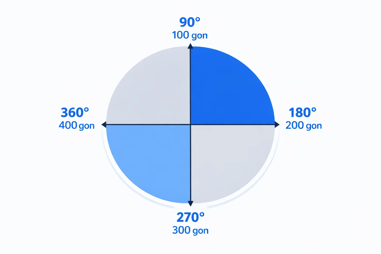
A full circle is 400 gon and 360°. Dividing 360 by 400 gives 0.9. That's it — no lookup tables needed, no special cases. Going the other direction? Multiply degrees by 10/9 to get gradians. Both conversions are exact with no rounding involved in the factor itself.
Reading a Total Station Display in Gon
If you've just unboxed a Leica TS16, Trimble S7, or Topcon GT-1003, and the angle display reads something like 137.4582 gon, here's what you're looking at. The number before the decimal is whole gradians. The four digits after the decimal point are decimal fractions of a gradian — not minutes and seconds. This trips up newcomers from degree-based backgrounds where "137.45" might look like 137 degrees 45 minutes.
It isn't. In gon, 137.4582 means exactly 137 and 4582 ten-thousandths of a gradian. Each 0.0001 gon (a "deci-milligon") corresponds to roughly 0.324 arc-seconds. So those four decimal places give you sub-arc-second precision — more than enough for boundary surveys and construction layout.
Most instruments show a small "gon" or "g" indicator next to the angle readout. On Leica's FlexField software, the unit label sits in the upper corner of the angle panel. On Trimble Access, it's embedded in the measurement line. Always confirm that indicator before recording. Writing down a gon value as if it were degrees will throw your entire traverse off by roughly 10%.
Bearing Notation in Gon Explained
Surveying bearings in gon follow the same clockwise-from-north convention as degree bearings, but the scale runs 0 to 400 instead of 0 to 360. North is 0 (or 400) gon, east is 100 gon, south is 200 gon, and west is 300 gon. A bearing of 312.89 gon therefore points west-northwest — past 300 gon (due west) by 12.89 gon.
Field notes from European survey crews often write bearings as a bare decimal: "Pt 7 → Pt 8: 247.3150 gon." No degree symbol, no minutes, no seconds — just the decimal gon value. This is cleaner than the degrees-minutes-seconds format used in North American surveys, and it's one reason European surveyors resist switching to degrees: the notation is simpler and less error-prone.
Converting Field Readings for Architectural Plans
Architects work in degrees. Full stop. Your site plan, your floor plan, your section drawing — all dimensioned in degrees (or sometimes degrees-minutes-seconds). When a survey crew hands off data collected in gon, someone needs to convert before that data reaches the design team.
The workflow looks like this: export raw angle data from the total station software (Leica Infinity, Trimble Business Center, or Topcon MAGNET Office), multiply every gon value by 0.9, and deliver the results in decimal degrees or DMS depending on the architect's preference. Most survey office software can do this automatically in the export settings, but if you're manually checking a few readings — or an architect calls you from the construction trailer asking "what's 247.3150 gon in normal degrees?" — the mental math is fast: 247.3150 × 0.9 = 222.5835°.
One thing to watch: architects who work in DMS (degrees, minutes, seconds) need you to convert the decimal degrees further. Take 222.5835°: the 0.5835 portion equals 0.5835 × 60 = 35.01 minutes, so the final answer is 222° 35' 00". Getting this step wrong is how "off by a few minutes" errors creep into structural layouts.
Worked Examples from Real Instrument Readings
These use realistic total station readings — the kind you'd actually see on a job site:
- 137.4582 gon (a typical horizontal angle between two boundary points): 137.4582 × 0.9 = 123.7124°. That's 123° 42' 44.6" — an obtuse angle, common in irregular lot boundaries.
- 312.89 gon (a bearing in the fourth quadrant, past due west): 312.89 × 0.9 = 281.601°. In DMS, that's 281° 36' 03.6". A contractor would call this "roughly west-northwest."
- 99.9980 gon(what a "right angle" looks like in the field — never perfectly 100.0000): 99.9980 × 0.9 = 89.9982°. That 0.0018° deviation from 90° is about 6.5 arc-seconds, which over a 50-meter building footprint means a wall is roughly 1.6 mm off-square. Acceptable for most construction.
- 0.0000 gon (reference backsight direction): 0 × 0.9 = 0°. Your zero direction. Every other angle on the station is measured from here.
- 200.0000 gon (telescope flipped 180° for a face-2 measurement): 200 × 0.9 = 180°. If face-1 reads 137.4582 and face-2 reads 337.4585, the mean is 137.45835 gon — eliminating instrument collimation error.
Slope Percentage and the 100-Gon Right Angle
Here's a trick that makes surveyors love gradians: at small angles, the gon value roughly equals the slope percentage. A 1-gon vertical angle corresponds to a tangent of about 0.0157, and a 1% slope has a tangent of 0.01 — not identical, but close enough for quick mental estimates in the field.
The approximation holds well up to about 10 gon (9°), where the tangent is 0.158 versus the "exact" slope of 10% (tangent 0.1). Beyond 10 gon the gap widens fast. At 50 gon (45°), the tangent is 1.0 — a 100% slope — but nobody estimates slopes above about 15° in their head anyway.
Why does this matter? Because road designers, railway engineers, and pipeline surveyors constantly check slope percentages against angle readings. When the vertical circle of your total station reads 96 gon (measured from zenith), the slope angle is 100 − 96 = 4 gon, and you can immediately estimate a 4% downward grade. Try doing that in degrees: 90° − 86.4° = 3.6°, tangent = 0.0629 = 6.29%... not nearly as intuitive. The NOAA Surveying and Mapping techniques guide discusses these field estimation methods in its sections on vertical angle measurement.
Switching Between DEG and GRAD on Your Instrument
Sometimes you don't want to convert at all — you just want the instrument to display degrees directly. Every modern total station supports this, though the menu path varies by manufacturer:
- Leica TS16 / TS60:Press the function key (Fn), navigate to Settings → Units → Angle, and select "Degree" or "Deg'Min'Sec." The change applies immediately to the live display.
- Trimble S7 / S9:In Trimble Access, go to Instrument → Settings → Units. Change the angular unit to "Degrees." Stored observations remain in their original unit; only the display changes.
- Topcon GT-1003 / GT-600: From the main menu, enter Config → Observation Conditions → Angle. Toggle between GON, DEG, and MIL. A power cycle is not required.
A word of caution: switching units mid-project creates confusion in your field notes. If you started the day in gon, finish in gon. Do the conversion at the office, where you can batch-process everything consistently and double-check against the raw data. Mixed-unit field books are a recipe for blown traverses. The FIG (International Federation of Surveyors) publication on surveying best practices recommends maintaining a single angle unit throughout any measurement session.
When the Contractor Asks "What's That in Degrees?"
It happens on every mixed-nationality job site. You're staking out building corners, your instrument reads 137.4582 gon, and the site foreman walks over and asks, "What angle is that?" He means degrees. Always.
The fastest field method: drop the last digit, then subtract 10% of the remainder. So 137.4582 gon → round to 137.5 → subtract 13.75 → get 123.75°. That's close enough for a verbal answer on site (the exact value is 123.7124°). For a formal answer, pull out this converter or multiply precisely on your phone.
But here's the deeper issue: if you're regularly handing data to contractors and designers who think in degrees, consider whether your deliverables should be in degrees from the start. The survey itself can stay in gon — it's more efficient for fieldwork. But the staking report, the as-built drawing, the point export for the architect's CAD file? Convert those to degrees before they leave your office. It saves everyone time and eliminates the risk of someone on the receiving end not knowing what gon means.
A few contractors I've worked with assumed gon was a typo for "degrees." One grading crew set a road curve based on raw gon values without converting, producing an alignment that was off by about 14 meters at the far end of a 200-meter curve. The fix cost two days of rework. Multiply by 0.9 — it takes three seconds and prevents expensive mistakes.